
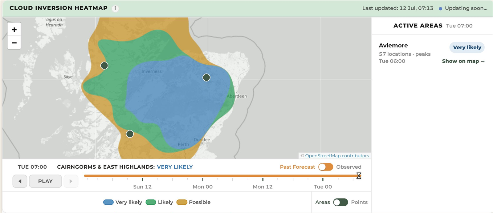
A Very likely Aberdeenshire cloud inversion forecast highlighted the Eastern Highlands about 46 hours before a cloud sea was photographed from Tap o’ Noth at dawn on 14 July 2026.
Quick answer: the forecast gave walkers and photographers nearly two days’ notice, continued to favour dawn as the event approached, and matched the mist-filled landscape later seen from the hill.
The forecast and outcome at a glance
| What readers need to know | Tap o’ Noth event |
|---|---|
| Forecast area | Aberdeenshire and the Eastern Highlands |
| Viewpoint | Tap o’ Noth near Rhynie |
| Event date | 14 July 2026 |
| First useful WeatherDuck capture | 12 July 2026 at 07:13 BST |
| Advance notice | About 46 hours |
| Forecast band | Very likely |
| Forecast confidence | Low at the long-range capture; high in the final pre-event capture |
| Best time | Around 06:00 BST |
| Modelled height | Lower edge of the capping inversion around 323 metres in the final profile; not an observed cloud-top measurement |
| What happened | Fog pooled below the upper hill, creating a cloud sea around neighbouring high ground |
Where did this cloud inversion happen?
Tap o’ Noth stands above Rhynie in Aberdeenshire, in the eastern Grampians and east of the main Cairngorm plateau. The hill reaches about 563 metres and provides wide views across the surrounding lower ground.
For trip planning, the useful forecast area is Aberdeenshire and the Eastern Highlands. Tap o’ Noth was the viewpoint from which the inversion was seen within that wider area.
What did WeatherDuck forecast?
A forecast saved on the morning of 12 July showed a Very likely cloud inversion opportunity for dawn on 14 July. The opportunity remained visible as newer forecasts arrived.
The final outlook before the event showed Likely at 05:00, Very likely at 06:00 and Likely at 07:00. In everyday terms, the forecast consistently pointed to dawn, with 06:00 offering the best chance.
How did the forecast change?
The first useful capture was saved at 07:13 BST on 12 July. It showed a Very likely signal across the 05:00–07:00 viewing window, but its long lead time meant forecast confidence was still low. By the final full capture at 23:09 BST on 13 July, confidence was high and the strongest hour had settled on 06:00.
| WeatherDuck capture | Approximate lead time | Signal for 05:00–07:00 on 14 July |
|---|---|---|
| 12 July, 07:13 BST | About 46 hours | Very likely throughout the window |
| 13 July, early morning | About one day | Likely at 05:00; Very likely at 06:00 and 07:00 |
| 13 July, 23:09 BST | About six hours | Likely at 05:00; Very likely at 06:00; Likely at 07:00 |
How much notice did the forecast give?
The first useful forecast was stored about 46 hours before the dawn viewing window. That is enough time to watch later updates, choose a suitable viewpoint and make a safe plan without committing to an early start immediately.
What time was best?
The final forecast favoured the period from 05:00 to 07:00 BST, with the strongest opportunity around 06:00 BST. The independent account describes the walker rising through fog around sunrise and seeing it flow around the neighbouring hills.
What conditions helped the inversion form?
The archived profile showed the familiar ingredients for a cloud inversion: near-saturated air low down, a sharp moisture change into drier air above, a strong temperature inversion acting as a lid and winds light enough for cloud to remain pooled over lower ground.
In the final pre-event profile, the lower edge of that capping inversion was modelled at approximately 323 metres. Tap o’ Noth reaches about 563 metres, so the forecast gave its upper slopes useful height above that boundary. The 323-metre figure is a coarse model estimate, not a measured cloud top, and the independent photographs do not establish an exact height.
The forecast input was Met Office Seamless, including UKV with Global fallback, delivered by Open-Meteo. WeatherDuck saved the surface and pressure-level evidence before the event.
What was actually seen?
A Walkhighlands report dated 14 July describes fog near Huntly, the walker emerging above it on Tap o’ Noth’s western shoulder, and mist flowing around the Hill of Noth as the sun rose. The accompanying photographs show the cloud sea around the surrounding high ground.
See the independent account: Tap o’ Noth sunrise inversion on Walkhighlands.
This observation is independent of WeatherDuck and confirms the event, place and sunrise timing. It is photographic evidence rather than a calibrated cloud-height observation.
What this case does — and doesn’t — prove
- It shows that a WeatherDuck forecast saved before the event highlighted the right wider area and dawn window.
- The forecast used the nearby Oyne capture point, about 16 kilometres from Tap o’ Noth, so this is regional verification rather than a summit instrument reading.
- The 323-metre boundary is modelled atmospheric evidence. It is not an observed cloud-top height.
- Possible, Likely and Very likely are model bands, not calibrated percentage probabilities or guarantees.
- One successful case is not an accuracy rate. A fair validation record must also include false alarms, misses and uncertain outcomes.
What can walkers and photographers learn from this?
- Watch the whole area: an inversion opportunity is regional, so compare several nearby valleys and viewpoints.
- Look for higher ground above lower cloud: a viewpoint needs to be high enough to rise through the cloud layer.
- Use the best-time window: in this case, the forecast correctly focused attention on dawn.
- Keep checking: the early signal was useful for planning, while the final update helped narrow down the best hour.
How should you use a cloud inversion forecast?
Treat Possible, Likely and Very likely as planning guidance rather than promises. Use an early outlook to shortlist a safe viewpoint, then check the newest forecast, cloud level, wind and mountain conditions before travelling.
Check the current UK cloud inversion forecast or browse the forecast verification archive.
Open the current inversion outlook near Tap o’ Noth, and read WeatherDuck’s data sources, limitations and safety guidance before planning a mountain outing.
For more forecast evidence, read the Torridon report and the Cadair Idris report.
Evidence and forecast details
| Detail | Archived evidence |
|---|---|
| First useful WeatherDuck capture | 12 July 2026, 07:13 BST |
| Final full pre-event capture | 13 July 2026, 23:09 BST |
| Target viewing period | 14 July 2026, 05:00–07:00 BST |
| Modelled vertical evidence | Strong inversion with its lower boundary near 323 metres in the final profile; this is not an observed cloud-top measurement |
| Forecast input | Met Office Seamless, including UKV with Global fallback, delivered by Open-Meteo and archived by WeatherDuck |
| Forecast location | Oyne capture point, approximately 16 kilometres from Tap o’ Noth |
| Observed outcome | Independent dated Walkhighlands report and photographs at sunrise; no instrumented cloud-height measurement |