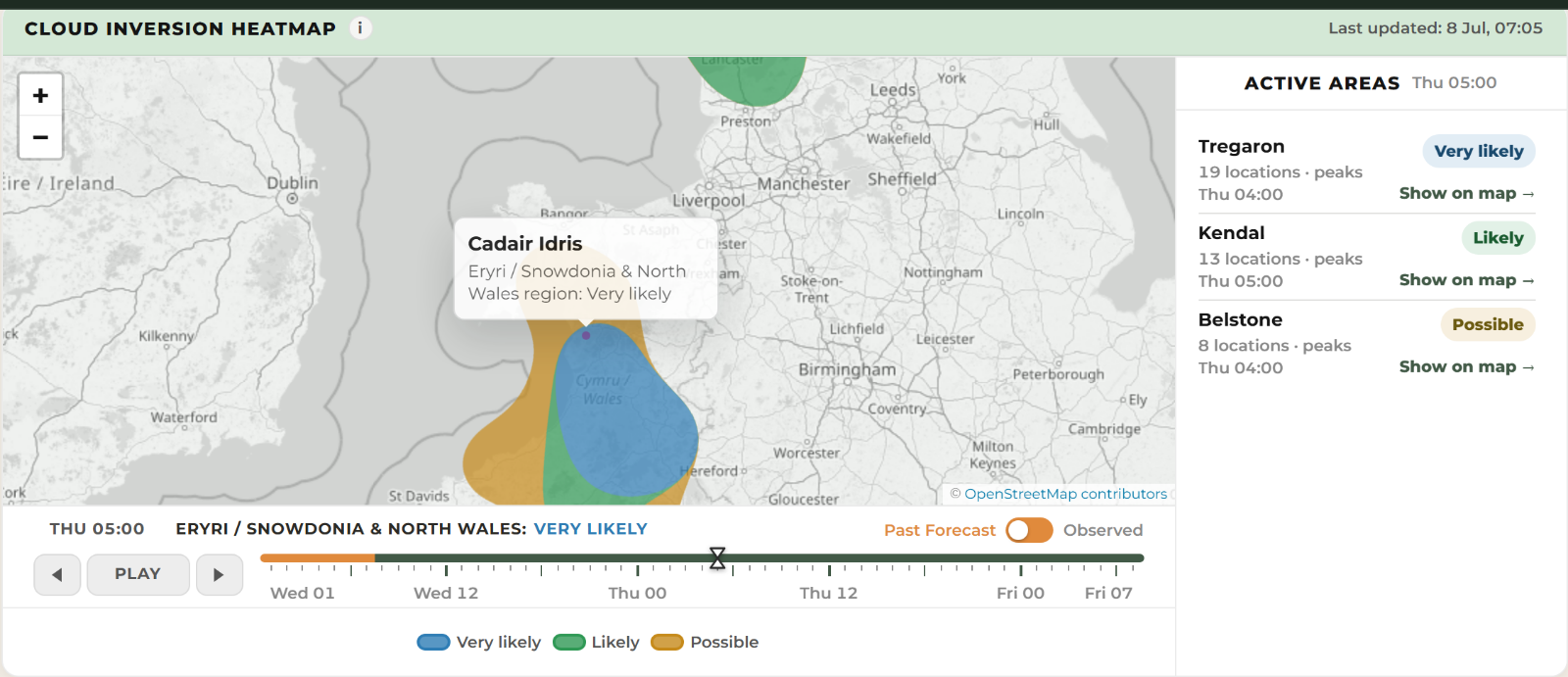
A Very likely Wales cloud inversion forecast highlighted mid Wales and southern Eryri about 21 hours before a cloud sea was photographed from Tyrrau Mawr on the Cadair Idris massif on 9 July 2026.
Quick answer: yes. WeatherDuck’s Very likely forecast area covered Cadair Idris the previous morning and remained over the ridge in eleven of the twelve updates before the dawn viewing window.
The forecast and outcome at a glance
| What readers need to know | Cadair Idris event |
|---|---|
| Forecast area | Mid Wales and southern Eryri |
| Viewpoint | Tyrrau Mawr on the Cadair Idris massif, above Barmouth and the Mawddach estuary |
| Event date | Thursday 9 July 2026 |
| First useful WeatherDuck capture | 8 July 2026 at 07:05 BST |
| Advance notice | About 21 hours |
| Forecast band | Very likely |
| Forecast confidence | Medium in the first useful capture |
| Best time | 04:00–07:00 BST, around sunrise at 05:03 |
| Modelled height | The estimate changed between updates; no defensible numerical cloud-top height is claimed |
| What happened | A sharp cloud deck lay below the ridge, with distant summits breaking through it and clear blue sky above |

Where did this cloud inversion happen?
Tyrrau Mawr is a 661-metre top on the Craig-las ridge, at the western end of the Cadair Idris massif in southern Eryri (Snowdonia). It looks out over Barmouth and the Mawddach estuary, and it is reached from the Cregennan lakes or by the pony path from the south.
For trip planning, the useful forecast area was the zone WeatherDuck drew across mid Wales and southern Eryri. Tyrrau Mawr sat inside it, with the nearest monitored points at Dolgellau and Barmouth, both under seven kilometres away.
What did WeatherDuck forecast?
The Wales cloud inversion forecast saved at 07:05 BST on 8 July put Thursday morning at Very likely for this area, with a best window of 02:00 to 05:00 and medium confidence. Later the same day the area was redrawn slightly and the window shifted to 04:00 to 07:00, which is the one that mattered.
WeatherDuck refreshes every two hours, and the area kept covering the ridge in update after update – eleven of the twelve refreshes between that first forecast and the viewing window. One update briefly weakened before the area returned. That persistence gave walkers more useful planning information than a signal appearing in only one update.
How did the forecast change?
| WeatherDuck capture | Forecast evolution |
|---|---|
| 8 July, 07:05 BST | Very likely with medium confidence; initial best window 02:00–05:00 |
| Later on 8 July | The area shifted slightly and the useful window moved to 04:00–07:00 |
| Through the viewing window | The forecast area covered the ridge in eleven of twelve updates; one update briefly weakened before it returned |
This history is more informative than selecting one favourable screenshot after the event. It shows both the persistence of the regional signal and the update that did not agree.
How much notice did the forecast give?
The first useful forecast was stored about 21 hours before the dawn window. On top of that, the area was still showing when a walker would realistically have made the call the night before, and again when they set off. That combination – useful notice plus a signal that holds – is what makes a forecast worth acting on.
What time was best?
Sunrise was at 05:03 BST and the settled forecast window ran from 04:00 to 07:00. As it turned out the cloud sea lasted well beyond that: the walker was out for six and a half hours over eighteen kilometres and still had the inversion for the views over the estuary.
What conditions helped the inversion form?
The archived atmospheric profile showed the full set of ingredients: a temperature lid holding the cold air down, valley air moist enough to condense, a sharp moisture contrast at the boundary and a clear cap of dry air above the cloud. Winds were light enough to leave the deck sitting in place rather than mixing it away, and the favourable spell was expected to last around ten hours.
One thing the forecast was less sure about was the height of the cloud top. Estimates moved between updates, and the archived evidence used for this report does not support one stable, defensible number at Tyrrau Mawr. The photographs show the ridge above a sharp deck, but they are not a calibrated height measurement, so this article does not turn the changing model estimates into a claimed observed height.
The forecast input was Met Office Seamless, including UKV with Global fallback, delivered by Open-Meteo. WeatherDuck saved the surface and pressure-level evidence before the event.
What was actually seen?
A walker on the Tyrrau Mawr ridge that day photographed a sharp cloud deck below them, with the tops of distant hills breaking through on the horizon and clear blue sky overhead. Their account describes a hot day, eighteen kilometres and six and a half hours on the hill, with the estuary and Barmouth in view beneath the cloud.
Two other people photographed the same morning elsewhere in Eryri, roughly 40 kilometres north – one at Llyn Dywarchen and one from the summit of Yr Wyddfa (Snowdon). Satellite imagery from 06:40 that morning shows a broad band of low cloud lying along the whole western side of Britain.
See the independent account from the observed viewpoint: Barry Mcgauty’s Tyrrau Mawr cloud inversion photographs.
The viewpoint photographs were created independently of WeatherDuck. The other Eryri reports and 06:40 satellite image support the wider event, but none is an instrumented measurement of the cloud-top height.
What this case does — and doesn’t — prove
- It shows that a WeatherDuck forecast saved before the event covered the observed ridge and the right dawn period.
- It records forecast evolution honestly: the area held in eleven of twelve updates, while one update briefly weakened.
- The result verifies a regional forecast area, not every summit or valley inside it.
- No defensible numerical cloud-top height is available, and the photographs do not supply a measured one.
- One successful case is not an accuracy rate. A fair validation record must also include false alarms, misses and uncertain outcomes.
What can walkers and photographers learn from this?
- Watch whether the area holds: a zone that keeps reappearing update after update is worth far more than a one-off. This one held through eleven of twelve refreshes.
- Compare several updates: one update briefly weakened overnight before the area returned. Use the latest outlook alongside the wider trend.
- Treat the cloud-top height as a rough guide: it is the least certain number in the forecast, so favour a summit with margin to spare rather than one right at the estimated level.
- The area is bigger than one hill: the same forecast zone delivered here and at the far northern end of Eryri on the same morning, so look across the whole area for a viewpoint that suits you.
How should you use a cloud inversion forecast?
Treat Possible, Likely and Very likely as planning guidance rather than promises. Use an early outlook to shortlist a safe viewpoint, then check the newest forecast, cloud level, wind and mountain conditions before travelling.
Check the current UK cloud inversion forecast or browse the forecast verification archive.
Open the current Cadair Idris inversion outlook, and read WeatherDuck’s data sources, limitations and safety guidance before planning a mountain outing.
For more forecast evidence, read the Aberdeenshire cloud inversion report and the Torridon cloud inversion report.
Evidence and forecast details
| Detail | Archived evidence |
|---|---|
| First useful WeatherDuck capture | 8 July 2026, 07:05 BST |
| Target viewing period | 9 July 2026, 04:00–07:00 BST |
| Forecast persistence | Area covered the observed ridge in eleven of twelve updates before the viewing window |
| Modelled vertical evidence | Moist lower layer, temperature lid and dry air above; the changing height estimate is not published as a precise number |
| Forecast input | Met Office Seamless, including UKV with Global fallback, delivered by Open-Meteo and archived by WeatherDuck |
| Observed outcome | Independent dated photographs from Tyrrau Mawr, two further Eryri sightings and supporting satellite imagery; no instrumented cloud-height measurement |