WEATHERDUCK
WEATHER DUCK

Forecast Verification & Evidence

UK cloud inversion forecasts, checked against what happened

WeatherDuck compares forecasts saved before an event with later, independently published observations. Each report keeps the lead time, forecast evolution, atmospheric evidence, outcome and limitations together.

The short answer

What counts as forecast verification?

Regional verification means a forecast saved before the event covered the later observation in the relevant area and time window. It does not mean every summit or valley inside that area saw an inversion, or that one forecast point carried the same confidence as the wider map.

The current archive contains selected positive case studies. It shows that useful prior warnings occurred; it is not an overall WeatherDuck accuracy rate.

Evidence ledger

Every published verification report

3 published cases · newest reports first

  1. Case 01

    Event9 July 2026

    Very likely

    Regional verification · About 21 hours

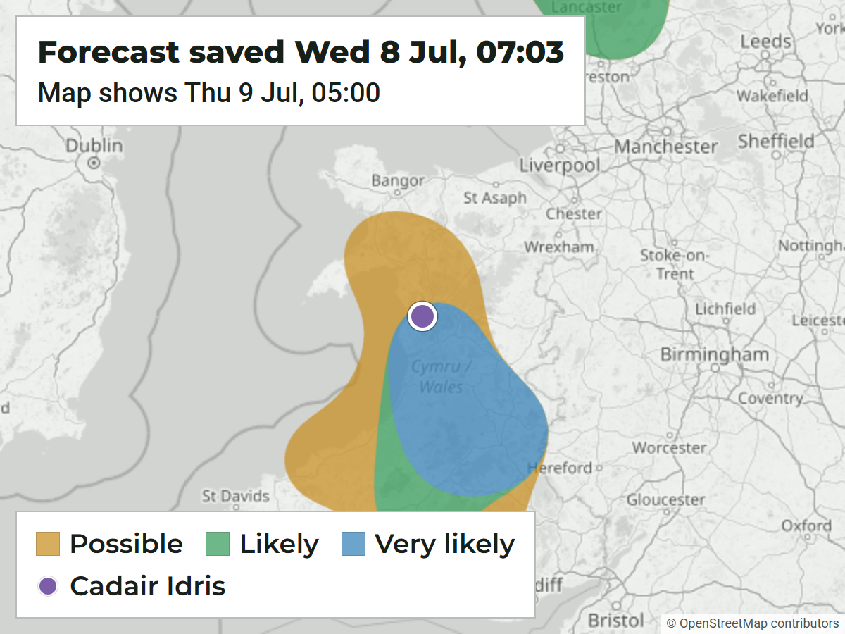
    Wales Cloud Inversion Forecast Verification: 21 Hours Ahead

    Forecast saved first

    A saved Wales forecast covered Cadair Idris. Its best window shifted from 02:00–05:00 to 04:00–07:00, and the area held over the ridge in 11 of 12 updates.

    Observed later

    Independent Tyrrau Mawr photographs, other dated Eryri reports and satellite imagery support the wider dawn event.

    Evidence limit: One update weakened, and changing model estimates do not support a defensible numerical observed cloud-top height.

    Read the full evidence report
  2. Case 02

    Event14 July 2026

    Likely

    Regional verification · About 42.9 hours

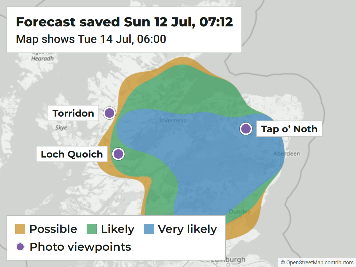
    Torridon Cloud Inversion Forecast Verification: 42 Hours Ahead

    Forecast saved first

    A saved regional outlook highlighted Torridon and the dawn period. The wider map held a Very likely core, while the location-scale report kept the more conservative Likely band.

    Observed later

    An independent Walkhighlands photograph taken at 05:57 BST shows mist and low cloud lying in the glens below Beinn Liath Mhòr.

    Evidence limit: The nearest individual point was weaker than the wider area, and the evidence does not support a numerical observed cloud-top height.

    Read the full evidence report
  3. Case 03

    Event14 July 2026

    Very likely

    Regional verification · About 46 hours

    Aberdeenshire Cloud Inversion Forecast Verification: 46 Hours Ahead

    Forecast saved first

    A saved Eastern Highlands forecast highlighted the dawn window before the event. Confidence developed from low to high, with 06:00 the final best hour.

    Observed later

    Independent, dated Walkhighlands photographs show a sunrise cloud sea from Tap o’ Noth.

    Evidence limit: The nearby Oyne capture point was about 16 km away. The roughly 323 m figure is the modelled lower edge of the capping inversion, not an observed cloud top.

    Read the full evidence report

Supporting observation catalogue

More dated inversion events to investigate

These 16 observed events also have a qualifying blob replay within the catalogue's 40 km evidence-matching range. They are still potential cases, not 16 forecast wins. Observations without a qualifying 40 km match are left out, so this shortlist is not an accuracy sample.

How to read the model panel: an archived forecast-input replay applies today's production formula to retained pre-event inputs. A retrospective hindcast is a single valid-time reconstruction and cannot establish issue time, persistence or lead.

The blob peak is the highest anchor score inside the matched area, not a score for the named summit. The small WeatherDuck graphics are illustrations; the linked source holds the original event photographs.

  • Replay
    Potential case

    Meall Mòr, Rannoch Moor

    A pre-sunrise report records thick fog clearing to reveal a broad inversion below the surrounding hills.

  • Replay
    Potential case

    Sgùrr a’ Mhaoraich, Lochaber

    Dated photographs show thick dawn cloud filling Loch Quoich and Loch Hourn beneath clear summits.

  • Replay
    Potential case

    Ben Aden, Knoydart

    A dated summit photograph shows a complete morning inversion across the Rough Bounds.

  • Replay
    Potential case

    Y Garn, Glyderau

    A dated photograph records Y Garn above a widespread winter cloud sea.

  • Replay
    Potential case

    Carnedd Llewelyn and Carnedd Dafydd, Eryri

    EXIF-dated photographs show the Carneddau above a cloud sea with a Brocken spectre.

  • Replay
    Potential case

    The Cobbler, Arrochar Alps

    The report describes emerging from mist into a 360-degree view above a broad cloud sea.

  • Replay
    Potential case

    Bidean nam Bian, Glencoe

    Dated photographs show surrounding mountains rising like islands from extensive low cloud.

  • Replay
    Potential case

    Ben Lawers and Beinn Ghlas

    A sunrise report records an extensive inversion below the two summits.

  • Replay
    Potential case

    Y Garn and Elidir Fawr, Eryri

    A dawn report shows Eryri summits floating above a large sunrise cloud sea.

  • Replay
    Potential case

    Ben Lawers, Killin

    The dated walking report records a strong summer morning cloud inversion.

  • Replay
    Potential case

    Gulvain, Locheil

    A dated walking report records a large surprise cloud sea extending toward Ben Nevis.

  • Replay
    Potential case

    Scafell Pike, Lake District

    A same-day video post shows the summit above a golden-hour cloud sea.

  • Replay
    Potential case

    Sgorr an Tarmachain, Sunart

    A dated trip report describes the summit above most of the cloud layer as the inversion lowered.

  • Replay
    Potential case

    An Teallach, Dundonnell

    A dated report records cloud falling below the ridge after Sail Liath and inversion views continuing along the traverse.

  • Replay
    Potential case

    Beinn Narnain, Arrochar

    The walking report records clearing the cloud on ascent and seeing a sea below Beinn Ime.

  • Replay
    Potential case

    Mither Tap, Bennachie

    A dated report shows an overnight cloud sea present at sunrise.

Visible methodology

How a forecast becomes a verification case

The same sequence is used for every report, so a reader can distinguish what the model suggested from what was actually observed.

  1. Archive the forecast

    Keep a WeatherDuck capture saved before the event, including its valid area, viewing window, band and confidence where available.

  2. Record its evolution

    Retain later changes, timing shifts and weaker updates instead of selecting only the most favourable screenshot.

  3. Check dated evidence

    Compare the forecast with a later observation published independently of WeatherDuck and identify its place and time.

  4. Classify the result

    State whether the evidence supports a regional or location-scale result, then keep any uncertainty and measurement limits beside it.

Forecast input: Met Office Seamless, including UKV with Global fallback, delivered by Open-Meteo and archived by WeatherDuck. Atmospheric profiles are modelled evidence; photographs and reports are observed evidence. One is not treated as an instrument reading of the other.

Read the record fairly

What this archive does not prove

Good evidence includes the boundary of the claim. These limits apply across the archive.

  • Possible, Likely and Very likely are model bands, not calibrated percentage probabilities.
  • Forecast areas are regional planning guidance, not promises for every summit or valley.
  • Photographs confirm visible conditions but are not instrumented cloud-height measurements.
  • A modelled inversion boundary is not automatically the observed cloud top.
  • Selected positive cases alone cannot establish an overall success rate.
  • A mature record should also include false alarms, misses and uncertain outcomes as evidence grows.

Evidence into action

Use the record, then check the newest forecast

Evidence cases show how earlier signals behaved. Your decision should still use the latest inversion window, cloud-layer heights, wind and mountain conditions.