
A dawn cloud sea was photographed below Gleouraich and Spidean Mialach above Loch Quoich on 14 July 2026, around 04:30–06:00 BST. Replaying forecasts saved before that morning with WeatherDuck’s current formula produces a Likely area covering the viewing location at 05:00 and 06:00.
This is a check of today’s forecasting method against previously saved forecasts. It does not establish which warning a visitor saw in July, or that an alert email was delivered.
The forecast and outcome at a glance
| Detail | Loch Quoich case |
|---|---|
| Event | 14 July 2026, approximately 04:30–06:00 BST |
| Area | Gleouraich and Spidean Mialach above Loch Quoich, Northwest Highlands |
| Forecast checkpoints | 13 July at 17:13 BST; 14 July at 03:07 BST |
| Replayed result | Likely area covering the reviewed point at 05:00 and 06:00 in both checkpoints |
| Observation | Jo Turnill’s independently published Facebook photographs and trip report |
| Evidence type | Current-formula replay of forecasts saved before the event |
| Location limit | Approximate area point; no measured camera GPS or observed cloud-top height |
The observed cloud sea
Jo Turnill shared photographs and a trip report in the public Facebook group I am bagging the Munros. The report describes an early start on Spidean Mialach and Gleouraich after an overnight stay near Loch Cuaich. The photographs show ridges above a broad cloud sea.
The event date and approximate 04:30–06:00 morning times were confirmed by Joss during the evidence review. They are approximate observation times, rather than camera timestamps or a measured duration for the entire cloud sea.
Original observation: Jo Turnill’s Loch Quoich trip report and photographs on Facebook. The photographs belong to their photographer and are viewed at the original source.
What the saved forecasts showed when replayed
Two useful checkpoints are the forecast available on the previous evening and the final saved forecast before the confirmed early-morning period. Both were saved before the observed event.
| Forecast saved | Replayed area at 05:00 | Replayed area at 06:00 |
|---|---|---|
| 13 July, 17:13 BST | Likely, covering the viewing location | Likely, covering the viewing location |
| 14 July, 03:07 BST | Likely, covering the viewing location | Likely, covering the viewing location |
The previous-evening forecast was available about eleven hours before the start of the confirmed observation period. The later update kept the Likely area over the location. The separate morning alert replay also met the current warning rules.
The closest individual forecast location was much less encouraging than the surrounding area. Stronger conditions around Glen Garry and Glen Affric helped the wider forecast cover the view. That distinction matters: this case supports a useful area forecast, rather than a promise of identical conditions at every nearby summit or valley.
Evidence maps: the two saved forecasts
Both maps show 06:00 BST on 14 July at the same scale; the replay also checked 05:00. Green means Likely, gold Possible and blue Very likely. The purple dot marks the fixed area point used in this review.
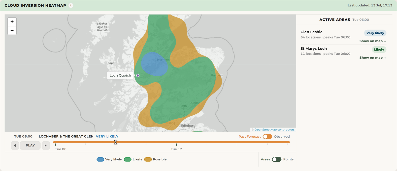
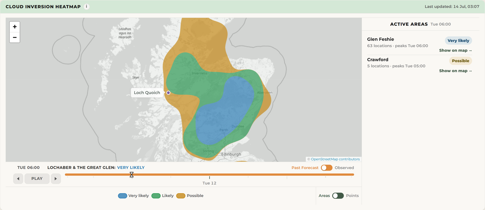
The point is approximately 57.097°N, 5.239°W and represents the reviewed Gleouraich–Spidean Mialach area. It is not a measured camera position. It sits close to the western edge of the Likely area, so the result supports an area forecast rather than exact-summit precision. These are maps recreated from the saved forecasts using the current map display, not screenshots taken in July or maps of the observed cloud. The display softens the outlines: in the final update, the dot appears in the gold fringe beside the green area. The underlying area-match check still returns Likely. This boundary case should be read as support for the surrounding area, not a precise Likely forecast at the dot. The Very likely wording beneath the map describes the wider region, not this location.
Why another case from 14 July is useful
WeatherDuck already holds evidence from Tap o’ Noth, Beinn Liath Mhòr and Meall Mòr on the same date. Loch Quoich adds another location and another independently published observation.
Those records help show the geographical extent and variation of the conditions, but they come from the same weather day. Loch Quoich adds a location, not a new independent event. Overall accuracy should therefore be checked both by location and with observations grouped by weather day. Evidence from other dates, including missed events and false alarms, is more valuable for testing reliability across different conditions.
The result and its limits
Result: a successful area match in the current-formula replay. The area overlaps both the accepted location and the confirmed morning period.
Possible, Likely and Very likely are forecast bands, not calibrated percentage probabilities. The photographs do not establish a measured cloud-top height or how long the inversion lasted. A selected successful case also cannot establish an overall hit rate or false-alarm rate; accepted missed events remain part of the wider evidence record.
The weather inputs are original Met Office Seamless forecasts delivered through Open-Meteo and saved by WeatherDuck before the event. Later observed weather and historical reanalysis were not substituted for those forecasts.
Check the current Loch Quoich forecast, read the Scotland inversion guide or browse the other forecast case studies. See forecast safety and data sources for guidance on using the outlook.